King George Island Map

King George Island

Maxwell Bay

Maxwell Bay at King George Island is a typical place to embark on the rest of your Antarctica cruise.

King George Bay

King George Bay is transitional between Sub-Antarctic and coastal zone of the Antarctic continent.

King George Island History

Who owns Antarctica?

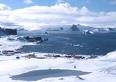
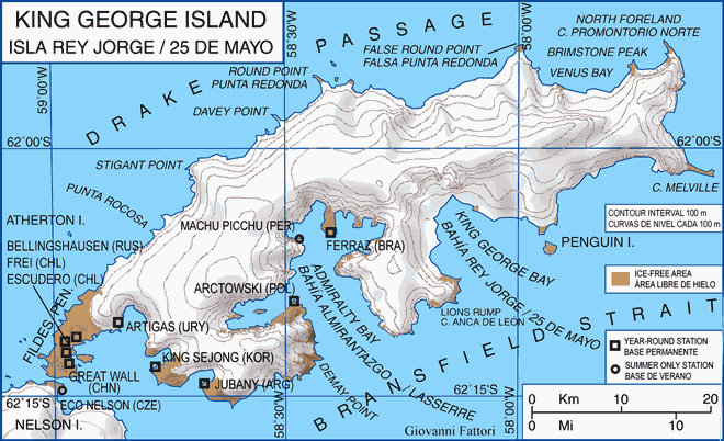
King George Island is the largest of the South Shetland Islands, situated at 120 kilometers off the coast of Antarctica in the Southern Ocean.

The Island was named after King George III. It was first claimed for Britain and incorporated as part of the Falkland Islands Dependencies in 1908, and presently regarded as part of the separate British Antarctic Territory.

The Island was claimed by Chile in 1940, and presently regarded as part of the Chilean Antarctic Territory. It was claimed also by Argentina in 1943, and presently regarded as part of Argentine Antarctica, called by the Argentines Isla Veinticinco de Mayo in honour of their National day. The USA and Russia do not recognize these claims, and have formally reserved their right to claim Antarctic territories.

Which Antarctica Expedition discovered King George Island?

King George Island was discovered by the British explorer William Smith in 1819.

williams point

Williams Point, discovered on 19 February 1819

King George Island Inhabitants

King George Island was the first spot in Antarctica for human settlers surviving winter

King George Island is approximately 95 kilometres long and 25 kilometres wide with a land area of 1150 square kilometres. Over 90% of the island's surface is permanently glaciated. In 1821, 11 men of the sealing vessel Lord Melville survived the winter on the island, the first men to do so in Antarctica.

The coastal areas of King George Island are home to a comparatively diverse selection of vegetation and animal life, including Elephant Seals, Weddell and Leopard seals, and Chinstrap and Gentoo penguins.

Human habitation of King George Island is limited to research stations belonging to Argentina, Brazil, Chile, China, South Korea, Peru, Poland, Russia, and Uruguay. Most of these stations are permanently manned, carrying out research into areas as diverse as Biology, Ecology, Geology, and Palaeontology.

maxwell bay

Maxwell Bay.
The buildings form part of the Russian and Chilean bases on King George Island.
The lake in the foreground serves as freshwater supply to the Chilean base.

In 2004, a Russian Orthodox church, Trinity Church, was opened on the island near Russia's Bellingshausen Station. The church, one of the southernmost in the world and one of the few permanent structures in Antarctica, is permanently manned by a priest.

A small amount of specialised Antarctica tourism activity also takes place during summer.

King George Island Map

King George Island Location

King George Island Map

King George Island Map

King George Island map: Antarctica

[Antarctica Cruises]

Antarctica Vacations: King George Island Map